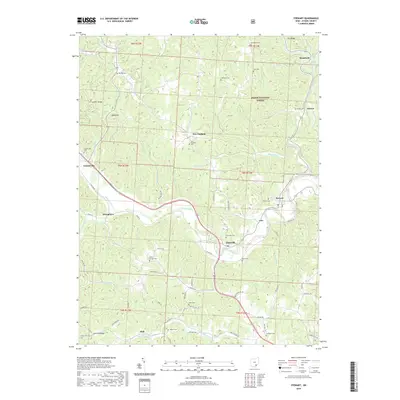
2019 Map of Stewart
USGS Topo · Published 2019About this map
Guysville and Stewart serve as the primary hubs along the winding Hocking River in this part of Athens County. The landscape is defined by its series of elevated ridges, such as Scatter Ridge and Tick Ridge, which rise above a complex network of waterways including Sharps Run, Federal Creek, and Miller Run. The settlement pattern follows both the river valley and these high ridges, connecting smaller communities like Canaanville and Broadwell via a web of township and county roads. Numerous burial sites are scattered throughout the hills, including Carthage Cem, Asbury Cem, and Sterling Cem, providing essential points of reference for genealogical research in Carthage Township. Large portions of the eastern terrain are preserved within the Wayne National Forest, where the topography remains relatively undeveloped compared to the settled river corridor where Cole and Stringtown are situated.
Find a feature on this map
86 named features on this map. Tap any name to fly to it.
Don’t see what you’re looking for? This feature index may not catch every label — zoom into the map to look around manually.
Map Details
Editions of this 2019 Stewart Map
This is the sole edition of this map. No revisions or reprints were ever made.
Other maps of this area

1903 · Athens
USGS Topo · 1:62,500

1904 · Chesterhill
USGS Topo · 1:62,500

1905 · Athens
USGS Topo · 1:62,500

1906 · Chesterhill
USGS Topo · 1:62,500

1907 · Pomeroy
USGS Topo · 1:62,500

1907 · Keno
USGS Topo · 1:62,500

1947 · Columbus
USGS Topo · 1:250,000

1949 · Clarksburg
USGS Topo · 1:250,000

1956 · Clarksburg
USGS Topo · 1:250,000
1960 · Alfred
USGS Topo · 1:24,000