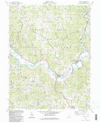
1994 Map of Stewart
USGS Topo · Published 1998About this map
The Hocking River carves a winding path through the center of this Athens County landscape, defining the development of river-bottom settlements like Guysville and Stewart. While the rugged uplands are largely preserved within the Wayne National Forest, the region's industrial history is marked by an active Oil Field in the north and a Quarry near the riverbanks. Local genealogy is well-represented through rural landmarks such as the Rome-Canaan High Sch and several country congregations, including East Canaan Ch and Asbury Ch. The map also preserves the memory of smaller locales and infrastructure, from the settlement at Broadwell to the transit history evidenced by Old Tunnel Road. Tributaries like Federal Creek and Mush Run intersect the ridges, illustrating the complex drainage patterns that shaped these Appalachian foothills.
Find a feature on this map
61 named features on this map. Tap any name to fly to it.
Don’t see what you’re looking for? This feature index may not catch every label — zoom into the map to look around manually.
Map Details
Editions of this 1994 Stewart Map
This is the sole edition of this map. No revisions or reprints were ever made.
Other maps of this area

1903 · Athens
USGS Topo · 1:62,500

1904 · Chesterhill
USGS Topo · 1:62,500

1905 · Athens
USGS Topo · 1:62,500

1906 · Chesterhill
USGS Topo · 1:62,500

1907 · Pomeroy
USGS Topo · 1:62,500

1907 · Keno
USGS Topo · 1:62,500

1947 · Columbus
USGS Topo · 1:250,000

1949 · Clarksburg
USGS Topo · 1:250,000

1956 · Clarksburg
USGS Topo · 1:250,000
1960 · Alfred
USGS Topo · 1:24,000
Featured Places
- Broadwell, Bern Township
- Canaan Township, OH
- Stewart, Rome Township
- Kilvert, Rome Township
- Stringtown, Canaan Township