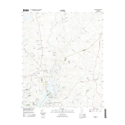
2014 Map of Stewart
USGS Topo · Published 2014About this map
Jackson Lake dominates the southern landscape of this 2014 survey, where the Alcovy River and Hardys Cr converge along the borders of Newton and Jasper counties. This modern view captures the residential expansion around the water, evidenced by the clustered developments of Turtles Cove, Alcovy Shores, and Lakeside Grove. Despite this growth, the map preserves a deep record of earlier agrarian and industrial settlement. Numerous burial grounds, including the Newton Factory Cem and Red Oak Cem, are scattered across the terrain, reflecting the area's ancestral roots near the former manufacturing sites of Factory Shoals. In the eastern reaches, the Jasper Lookout Tower stands near Prospect, while Waters Bridge provides a key crossing point for Ga-212 as it navigates the intricate shoreline of the reservoir.
Find a feature on this map
158 named features on this map. Tap any name to fly to it.
Don’t see what you’re looking for? This feature index may not catch every label — zoom into the map to look around manually.
Map Details
Editions of this 2014 Stewart Map
This is the sole edition of this map. No revisions or reprints were ever made.
Other maps of this area

1896 · Monroe
USGS Topo · 1:125,000

1953 · Athens
USGS Topo · 1:250,000

1958 · Athens
USGS Topo · 1:250,000

1959 · Athens
USGS Topo · 1:250,000

1963 · Athens
USGS Topo · 1:250,000

1964 · Lloyd Shoals Dam
USGS Topo · 1:24,000
1964 · Jackson
USGS Topo · 1:24,000

1964 · Stewart
USGS Topo · 1:24,000

1964 · Worthville
USGS Topo · 1:24,000

1964 · Porterdale
USGS Topo · 1:24,000