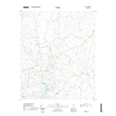
2020 Map of Stewart
USGS Topo · Published 2020About this map
Jackson Lake and the branching reaches of the Alcovy River define the southern half of this landscape at the intersection of Newton, Jasper, and Butts Counties. The complex shoreline is marked by numerous family-named points and inlets, such as Kitchen Neck, Pope Neck, and Connally Cove. This contemporary survey highlights the transition from traditional river-crossing points like Waters Bridge and industrial landmarks like Factory Shoals to modern lakeside communities like Alcovy Shores.
Find a feature on this map
159 named features on this map. Tap any name to fly to it.
Don’t see what you’re looking for? This feature index may not catch every label — zoom into the map to look around manually.
Map Details
Editions of this 2020 Stewart Map
This is the sole edition of this map. No revisions or reprints were ever made.
Other maps of this area

1896 · Monroe
USGS Topo · 1:125,000

1953 · Athens
USGS Topo · 1:250,000

1958 · Athens
USGS Topo · 1:250,000

1959 · Athens
USGS Topo · 1:250,000

1963 · Athens
USGS Topo · 1:250,000

1964 · Lloyd Shoals Dam
USGS Topo · 1:24,000
1964 · Jackson
USGS Topo · 1:24,000

1964 · Stewart
USGS Topo · 1:24,000

1964 · Worthville
USGS Topo · 1:24,000

1964 · Porterdale
USGS Topo · 1:24,000