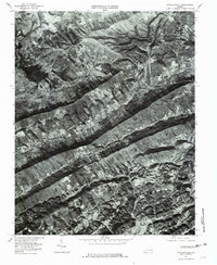
1976 Map of Stickleyville
USGS Topo · Published 1981About this map
Stickleyville and the surrounding Lee County settlements are defined by the dramatic linear geology of southwestern Virginia, where agricultural clearings are confined to narrow valleys between forested heights. This 1976 orthophotograph reveals the distinct topographical constraints of the region, as the massive spine of Wallen Ridge separates the watershed of the Powell River from the tributaries of the North Fork Clinch River. Small communities like Dot, Canton, and Fairview follow the watercourses, while the high point at Buzzard Roost overlooks the rugged landscape. The map shows the established transportation corridors that utilize these natural gaps, including the Station railroad line and the winding roads following Wallen Creek, illustrating how the physical environment dictated the placement of early Virginia mountain homesteads and road networks.
Find a feature on this map
13 named features on this map. Tap any name to fly to it.
Don’t see what you’re looking for? This feature index may not catch every label — zoom into the map to look around manually.
Map Details
Editions of this 1976 Stickleyville Map
This is the sole edition of this map. No revisions or reprints were ever made.
Other maps of this area

1887 · Jonesville
USGS Topo · 1:125,000

1891 · Jonesville
USGS Topo · 1:125,000

1894 · Estillville
USGS Topo · 1:125,000

1916 · Nolansburg
USGS Topo · 1:48,000

1919 · Nolansburg
USGS Topo · 1:62,500

1921 · Big Stone Gap
USGS Topo · 1:48,000

1922 · Big Stone Gap
USGS Topo · 1:62,500

1929 · Big Stone Gap
USGS Topo · 1:62,500

1935 · Kyles Ford
USGS Topo · 1:24,000

1935 · Looneys Gap
USGS Topo · 1:24,000