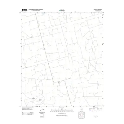
2012 Map of Stiles
USGS Topo · Published 2012About this map
Stiles occupies the heart of this Reagan County landscape, once serving as the original county seat in the early twentieth century before the railroad bypassed it. This modern survey reflects the area's transition into a landscape defined by ranching and resource extraction, notably the Stiles Oil Field to the east. The terrain is marked by seasonal drainage patterns, including High Lonesome Draw and Gardener Draw, which intersect the expansive grid of private ranch roads and lanes. Local family history is preserved at the Stiles Cem, situated just south of the main settlement. The map documents a network of rural thoroughfares such as Schwertner Blacktop, Ham Ranch Rd, and Patterson Ranch Rd, illustrating the continued importance of land access in this sparsely populated portion of the Permian Basin.
Find a feature on this map
16 named features on this map. Tap any name to fly to it.
Don’t see what you’re looking for? This feature index may not catch every label — zoom into the map to look around manually.
Map Details
Editions of this 2012 Stiles Map
This is the sole edition of this map. No revisions or reprints were ever made.
Other maps of this area

1928 · Rankin
USGS Topo · 1:125,000

1954 · San Angelo
USGS Topo · 1:250,000

1958 · San Angelo
USGS Topo · 1:250,000

1965 · San Angelo
USGS Topo · 1:250,000

1970 · Stiles NW
USGS Topo · 1:24,000

1970 · Moore Hill
USGS Topo · 1:24,000

1970 · Garrison Draw
USGS Topo · 1:24,000

1970 · Gardener Draw
USGS Topo · 1:24,000
1970 · Divide Draw
USGS Topo · 1:24,000

1970 · Stiles
USGS Topo · 1:24,000