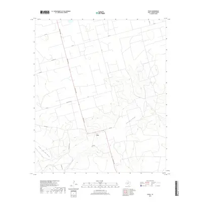
2019 Map of Stiles
USGS Topo · Published 2019About this map
Stiles anchors this West Texas landscape in Reagan County, a location historically significant as a former county seat before regional shifts moved the center of governance elsewhere. The map documents a topography defined by intermittent drainage patterns, most notably Centralia Draw and High Lonesome Draw, which carve their way through the arid terrain. The settlement itself is centered near the intersection of Ranch Rd 1800 and Vinson Rd, with the Stiles Cem providing a critical reference point for genealogists and local historians. This 2019 survey shows a network of named ranch roads such as Patterson Ranch Rd and Ham Ranch Rd, illustrating the continued importance of large-scale landholdings and the specialized transportation routes, including the uniquely named Schwertner Blktp, that support the region's agricultural and ranching legacy.
Find a feature on this map
20 named features on this map. Tap any name to fly to it.
Don’t see what you’re looking for? This feature index may not catch every label — zoom into the map to look around manually.
Map Details
Editions of this 2019 Stiles Map
This is the sole edition of this map. No revisions or reprints were ever made.
Other maps of this area

1928 · Rankin
USGS Topo · 1:125,000

1954 · San Angelo
USGS Topo · 1:250,000

1958 · San Angelo
USGS Topo · 1:250,000

1965 · San Angelo
USGS Topo · 1:250,000

1970 · Stiles NW
USGS Topo · 1:24,000

1970 · Moore Hill
USGS Topo · 1:24,000

1970 · Garrison Draw
USGS Topo · 1:24,000

1970 · Gardener Draw
USGS Topo · 1:24,000
1970 · Divide Draw
USGS Topo · 1:24,000

1970 · Stiles
USGS Topo · 1:24,000