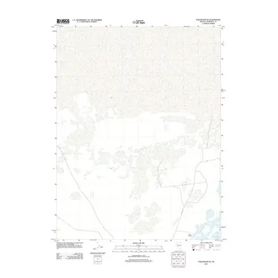
2011 Map of Stillwater NE
USGS Topo · Published 2011About this map
The low-lying wetlands and alkali flats of Churchill County, Nevada, characterize this area as it appeared in the early 21st century. The landscape is defined by the shallow, shifting waters of Willow Lake and Lead Lake, which sit at the heart of an intricate network of desert drainage patterns and seasonal ponds. Human presence is concentrated near Millens Landing in the south, where the local road network provides access to these isolated water bodies. Significant routes including Westside Rd and N Rd cut across the arid terrain, illustrating the sparse but essential transportation infrastructure required for navigating this part of the Great Basin.
Find a feature on this map
5 named features on this map. Tap any name to fly to it.
Don’t see what you’re looking for? This feature index may not catch every label — zoom into the map to look around manually.
Map Details
Editions of this 2011 Stillwater NE Map
This is the sole edition of this map. No revisions or reprints were ever made.
Other maps of this area

1908 · Carson Sink
USGS Topo · 1:250,000

1910 · Carson Sink
USGS Topo · 1:250,000

1950 · Stillwater
USGS Topo · 1:62,500

1951 · Carson Sink
USGS Topo · 1:62,500

1957 · Reno
USGS Topo · 1:250,000

1959 · Reno
USGS Topo · 1:250,000

1960 · Reno
USGS Topo · 1:250,000
1969 · Lone Rock SW
USGS Topo · 1:24,000

1969 · Pintail Bay
USGS Topo · 1:24,000

1969 · Foxtail Lake
USGS Topo · 1:24,000