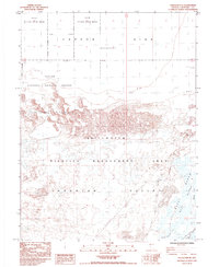
1985 Map of Stillwater NE
USGS Topo · Published 1985About this map
Fallon National Wildlife Refuge and the Stillwater Wildlife Management Area dominate this section of the northern Lahontan Valley. This environment is characterized by the complex drainage of the Carson Sink, where the desert floor is broken by extensive Alkali Flats and shifting Sand Dunes. The map reveals a highly managed hydrological landscape, featuring the Lead Dikes Bypass Canal and Millens Channel which direct water through the Marsh lands toward Willow Lake.
Find a feature on this map
19 named features on this map. Tap any name to fly to it.
Don’t see what you’re looking for? This feature index may not catch every label — zoom into the map to look around manually.
Map Details
Editions of this 1985 Stillwater NE Map
This is the sole edition of this map. No revisions or reprints were ever made.
Other maps of this area

1908 · Carson Sink
USGS Topo · 1:250,000

1910 · Carson Sink
USGS Topo · 1:250,000

1950 · Stillwater
USGS Topo · 1:62,500

1951 · Carson Sink
USGS Topo · 1:62,500

1957 · Reno
USGS Topo · 1:250,000

1959 · Reno
USGS Topo · 1:250,000

1960 · Reno
USGS Topo · 1:250,000
1969 · Lone Rock SW
USGS Topo · 1:24,000

1969 · Pintail Bay
USGS Topo · 1:24,000

1969 · Foxtail Lake
USGS Topo · 1:24,000