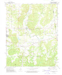
1972 Map of Stilwell East
USGS Topo · Published 1974About this map
Fairfield and the eastern outskirts of Stilwell anchor this landscape along the Oklahoma Arkansas state line in the early 1970s. The region is defined by a dense network of rural spiritual and community centers, including United Ch, Faith Tabernacle, and Oak Grove Ch, alongside numerous family and community burial grounds such as Fourkiller Cem and Chalk Bluff Cem. The Old Indian Treaty Boundary runs North-South through the eastern portion of the map, a significant historical marker that intersects the rugged topography of Davis Mountain and Killer Mountain. Waterways like Baron Creek and Evansville Creek wind through the valleys, supporting small agricultural holdings and providing drainage for the surrounding heights. Industrial activity is represented by scattered Gravel Pit operations, while the K C S railroad serves as the primary transportation artery for the region's commerce.
Find a feature on this map
40 named features on this map. Tap any name to fly to it.
Don’t see what you’re looking for? This feature index may not catch every label — zoom into the map to look around manually.
Map Details
Editions of this 1972 Stilwell East Map
This is the sole edition of this map. No revisions or reprints were ever made.
Other maps of this area

1898 · Winslow #3
USGS Topo · 1:62,500

1898 · Tahlequah
USGS Topo · 1:125,000

1898 · Winslow
USGS Topo · 1:125,000

1901 · Winslow
USGS Topo · 1:125,000

1901 · Tahlequah
USGS Topo · 1:125,000

1905 · Tahlequah
USGS Topo · 1:125,000

1946 · Fort Smith
USGS Topo · 1:250,000

1965 · Fort Smith
USGS Topo · 1:250,000

1967 · Fort Smith
USGS Topo · 1:250,000

1969 · Natural Dam
USGS Topo · 1:24,000