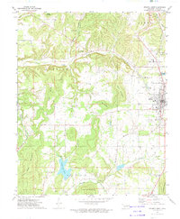
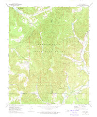
1972 Map of Stilwell West
USGS Topo · Published 1974About this map
The Kansas City Southern corridor defines the eastern edge of this Adair County landscape, linking the regional hub of Stilwell to the surrounding hills and hollows. During the early 1970s, this area maintained a balance of municipal utility and rural community life, evidenced by the presence of the Stilwell City Lake and the Stilwell Airport alongside numerous country churches and schools. The topography is marked by several prominent summits including Goat Mountain and West Mountain, which overlook the winding paths of Caney Creek and Sallisaw Creek. These waterways and mountains historically partitioned the countryside into distinct settlements like Stony Point, Zion, and Blanch, each anchored by local landmarks such as Maryetta Sch or Pilgrims Rest Ch. Genealogists will find a high density of burial grounds, from New Hope Cem near the town center to the more remote Doublehead Cem.
Find a feature on this map
47 named features on this map. Tap any name to fly to it.
Don’t see what you’re looking for? This feature index may not catch every label — zoom into the map to look around manually.
Map Details
Editions of this 1972 Stilwell West Map
This is the sole edition of this map. No revisions or reprints were ever made.
Other maps of this area

1898 · Tahlequah
USGS Topo · 1:125,000

1901 · Tahlequah
USGS Topo · 1:125,000

1905 · Tahlequah
USGS Topo · 1:125,000

1946 · Fort Smith
USGS Topo · 1:250,000

1965 · Fort Smith
USGS Topo · 1:250,000

1967 · Fort Smith
USGS Topo · 1:250,000
1972 · Christie
USGS Topo · 1:24,000
1972 · Tailholt
USGS Topo · 1:24,000
1972 · Westville
USGS Topo · 1:24,000
1972 · Bunch
USGS Topo · 1:24,000