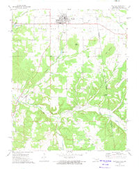
1972 Map of Westville
USGS Topo · Published 1974About this map
The Kansas City Southern railroad serves as the central artery for this corner of Adair County during the early 1970s, anchoring the community of Westville. To the north and west, the landscape is marked by the legacy of transit, with segments of an Old RR Grade and Old Railroad Grade carving through the terrain near the Westville Reservoir. The map provides a detailed look at local genealogy through its numerous family and community burial grounds, such as Foreman Cem and Crittenden Cem, alongside landmarks like Wrights Chapel and the Community Hall in Piney. One of the most significant historical markers is the Indian Treaty Boundary, which runs north-south across the rugged eastern ridges of West Mountain and Sugartree Mountain, delineating a critical line of jurisdictional and cultural history on the Oklahoma-Arkansas border.
Find a feature on this map
39 named features on this map. Tap any name to fly to it.
Don’t see what you’re looking for? This feature index may not catch every label — zoom into the map to look around manually.
Map Details
Editions of this 1972 Westville Map
This is the sole edition of this map. No revisions or reprints were ever made.
Other maps of this area

1898 · Tahlequah
USGS Topo · 1:125,000

1898 · Winslow
USGS Topo · 1:125,000

1899 · Fayetteville
USGS Topo · 1:125,000

1899 · Siloam Springs
USGS Topo · 1:125,000

1901 · Winslow
USGS Topo · 1:125,000

1901 · Fayetteville
USGS Topo · 1:125,000

1901 · Tahlequah
USGS Topo · 1:125,000

1903 · Siloam Springs
USGS Topo · 1:125,000

1904 · Siloam Springs
USGS Topo · 1:125,000

1904 · Fayetteville
USGS Topo · 1:125,000