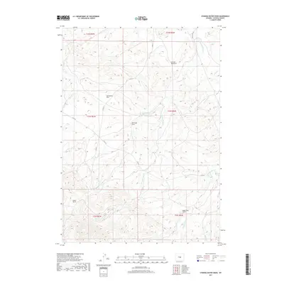
2017 Map of Stinking Water Creek
USGS Topo · Published 2017About this map
Stinking Water Creek and its many tributaries carve through this high-altitude landscape of central Wyoming, where the headwaters of Middle Fork Casper Creek and Poison Spider Creek originate. The terrain is defined by dramatic geological cuts such as Eagles Nest Canyon and Snider Basin, showing a complex system of draws and drainage patterns like McClanahan Draw and Rhobaugh Draw. A lone landmark, the Neil Bell Monument, stands near the intersection of various ranch roads in the northern reaches of the quadrangle. Transport through this open range is maintained by a network of county roads including Co RD 211 and Powder River Road, which follow the natural contours of the high basins and creek beds. This map provides an essential record of the water sources and named landmarks vital to the livestock and land management history of Natrona County.
Find a feature on this map
23 named features on this map. Tap any name to fly to it.
Don’t see what you’re looking for? This feature index may not catch every label — zoom into the map to look around manually.
Map Details
Editions of this 2017 Stinking Water Creek Map
This is the sole edition of this map. No revisions or reprints were ever made.
Other maps of this area

1955 · Casper
USGS Topo · 1:250,000

1958 · Casper
USGS Topo · 1:250,000

1959 · Gaylord Reservoir
USGS Topo · 1:24,000

1959 · Eightmile Draw
USGS Topo · 1:24,000

1959 · Broad Mesa
USGS Topo · 1:24,000
1959 · Mc Rae Gap
USGS Topo · 1:24,000

1959 · Horse Creek Springs
USGS Topo · 1:24,000
1959 · Stinking Water Creek
USGS Topo · 1:24,000

1959 · Saddle Rock
USGS Topo · 1:24,000

1959 · Barlow Gap
USGS Topo · 1:24,000