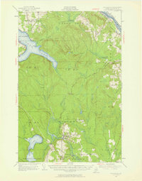
1953 Map of Stockholm
USGS Topo · Published 1958About this map
The Bangor and Aroostook railroad defines the industrial landscape of northern Maine in the early 1950s, cutting through heavily timbered tracts and connecting small settlements like Stockholm and Jemtland. The area's dependence on timber and rail transport is evident in the presence of specialized locations such as Dangle Mill, Collins Siding, and Martins Siding. Along the northern border, the St John River separates the United States from Canada, paralleled by the Canadian Pacific rail line.
Find a feature on this map
84 named features on this map. Tap any name to fly to it.
Don’t see what you’re looking for? This feature index may not catch every label — zoom into the map to look around manually.
Map Details
Editions of this 1953 Stockholm Map
2 editions found

Other maps of this area

1921 · Van Buren
USGS Topo · 1:250,000

1927 · Stockholm
USGS Topo · 1:48,000

1927 · Square Lake
USGS Topo · 1:48,000

1929 · Portage
USGS Topo · 1:62,500

1929 · Caribou
USGS Topo · 1:48,000

1930 · Fort Fairfield
USGS Topo · 1:48,000

1931 · Square Lake
USGS Topo · 1:62,500

1931 · Van Buren
USGS Topo · 1:48,000

1931 · Portage
USGS Topo · 1:62,500

1931 · Stockholm
USGS Topo · 1:62,500