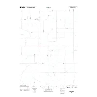
2013 Map of Stockport
USGS Topo · Published 2013About this map
Stockport anchors the northern edge of this Van Buren County landscape, where the intersection of Co HWY-j16 and Co HWY-w30 defines the local transport hub. The terrain is characterized by a series of south-flowing drainage systems, most notably Little Cedar Cr and Honey Cr, which carve through the agricultural grid. Smaller settlements like Utica, Pierceville, and Harrisburg are distributed along the primary north-south corridors, reflecting a traditional Iowa pattern of spaced rural hamlets connected by an orderly network of named roads such as Spruce Ave and Teal Ave. To the west, the winding path of Coppers Cr provides a break in the geometric road layout, while the small community of McVeigh sits near the eastern limits. This survey illustrates the contemporary layout of Van Buren County's rural infrastructure and its reliance on these established creek valleys for natural drainage.
Find a feature on this map
47 named features on this map. Tap any name to fly to it.
Don’t see what you’re looking for? This feature index may not catch every label — zoom into the map to look around manually.
Map Details
Editions of this 2013 Stockport Map
This is the sole edition of this map. No revisions or reprints were ever made.
Other maps of this area

1958 · Burlington
USGS Topo · 1:250,000

1961 · Burlington
USGS Topo · 1:250,000

1963 · Burlington
USGS Topo · 1:250,000

1968 · Bonaparte
USGS Topo · 1:24,000

1968 · Keosauqua
USGS Topo · 1:24,000

1968 · Farmington
USGS Topo · 1:24,000
1980 · Fairfield South
USGS Topo · 1:24,000

1980 · Lockridge West
USGS Topo · 1:24,000

1980 · Lockridge East
USGS Topo · 1:24,000
1981 · Mount Zion
USGS Topo · 1:24,000