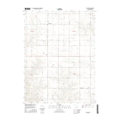
2015 Map of Stockport
USGS Topo · Published 2015About this map
Stockport and the surrounding Van Buren County countryside are defined by a rhythmic grid of rural roads and the winding paths of several creeks. The settlement of Utica sits centrally, while Harrisburg occupies the southeastern corner of the quadrangle. This area of Iowa preserves a high density of small family or community burial grounds, illustrating the early settlement patterns and genealogical heritage of the region. Distinctive sites include Fordyce Cem, Trumbo Cem, and the uniquely named Stone-Tree Cem. Waterways like Little Cedar Cr and Honey Cr carve through the agricultural landscape, creating natural breaks in the otherwise uniform township and range layout. The map also traces the path of Rte w30 and Rte j16, which connect these small rural hubs.
Find a feature on this map
53 named features on this map. Tap any name to fly to it.
Don’t see what you’re looking for? This feature index may not catch every label — zoom into the map to look around manually.
Map Details
Editions of this 2015 Stockport Map
This is the sole edition of this map. No revisions or reprints were ever made.
Other maps of this area

1958 · Burlington
USGS Topo · 1:250,000

1961 · Burlington
USGS Topo · 1:250,000

1963 · Burlington
USGS Topo · 1:250,000

1968 · Bonaparte
USGS Topo · 1:24,000

1968 · Keosauqua
USGS Topo · 1:24,000

1968 · Farmington
USGS Topo · 1:24,000
1980 · Fairfield South
USGS Topo · 1:24,000

1980 · Lockridge West
USGS Topo · 1:24,000

1980 · Lockridge East
USGS Topo · 1:24,000
1981 · Mount Zion
USGS Topo · 1:24,000