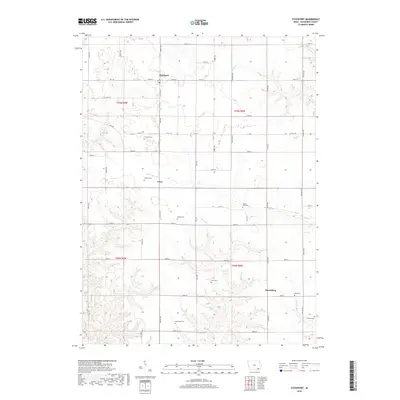
2018 Map of Stockport
USGS Topo · Published 2018About this map
Stockport anchors this Van Buren County landscape, where the Jefferson County line meets a rural grid of gravel roads and creek drainages. The area is defined by its transition from the plateau-like farm ground around Utica to the more dissected terrain of the Harrisburg vicinity. Genealogists will find a high density of rural burial grounds, including the Stone-Tree Cem, Fordyce Cem, and Trumbo Cem, reflecting a long history of family farmstead settlement. Drainage patterns are established by several winding waterways such as Little Cedar Cr, Honey Cr, and Rock Cr, which cut through the agricultural sections. The map reveals the persistence of small community centers and the foundational road network of southeastern Iowa, serving as a contemporary record of long-established land divisions and property boundaries.
Find a feature on this map
52 named features on this map. Tap any name to fly to it.
Don’t see what you’re looking for? This feature index may not catch every label — zoom into the map to look around manually.
Map Details
Editions of this 2018 Stockport Map
This is the sole edition of this map. No revisions or reprints were ever made.
Other maps of this area

1958 · Burlington
USGS Topo · 1:250,000

1961 · Burlington
USGS Topo · 1:250,000

1963 · Burlington
USGS Topo · 1:250,000

1968 · Bonaparte
USGS Topo · 1:24,000

1968 · Keosauqua
USGS Topo · 1:24,000

1968 · Farmington
USGS Topo · 1:24,000
1980 · Fairfield South
USGS Topo · 1:24,000

1980 · Lockridge West
USGS Topo · 1:24,000

1980 · Lockridge East
USGS Topo · 1:24,000
1981 · Mount Zion
USGS Topo · 1:24,000