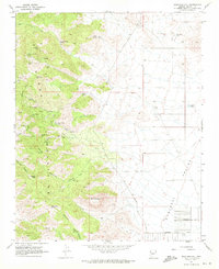
1968 Map of Stockton Hill
USGS Topo · Published 1971About this map
The Cerbat Mountains rise sharply in this late-1960s survey, revealing a landscape defined by an intensive mining history. This area north of Kingman is dotted with dozens of distinct claims, from the Stockton Mine and Jordan Mine to the White Eagle Mine and De La Fontaine Mine. These sites follow the high ridges near Cerbat Peak and Silver Mtn, where steep topography necessitated an intricate network of Jeep Trails for access.
Find a feature on this map
48 named features on this map. Tap any name to fly to it.
Don’t see what you’re looking for? This feature index may not catch every label — zoom into the map to look around manually.
Map Details
Editions of this 1968 Stockton Hill Map
4 editions found
Other maps of this area

1886 · Diamond Creek
USGS Topo · 1:250,000

1886 · Camp Mohave
USGS Topo · 1:250,000

1892 · Diamond Creek
USGS Topo · 1:250,000

1892 · Camp Mohave
USGS Topo · 1:250,000

1939 · Chloride
USGS Topo · 1:48,000

1942 · Camp Mohave
USGS Topo · 1:250,000

1944 · Chloride
USGS Topo · 1:62,500

1947 · Kingman
USGS Topo · 1:250,000

1948 · Kingman
USGS Topo · 1:250,000

1948 · Williams
USGS Topo · 1:250,000