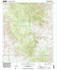
1996 Map of Stockton Pass
USGS Topo · Published 2002About this map
The Pinaleno Mountains dominate this high-altitude landscape in the Coronado National Forest, where topography rises sharply from the eastern desert floor to peaks like Ladybug Peak and Maverick Mountain. The map centers on the strategic Stockton Pass, a natural gateway used for livestock and travel between the Aravaipa and Gila valleys. Water is the defining constraint of this region, evidenced by the high density of named springs and tanks such as Alder Spring, Shake Spring, and the Bar X Tank. These water sources supported small-scale ranching operations, including the C N Ranch and Jernigan Ranch, which sit along the drainage of Stockton Wash. The presence of several benchmarked wells, such as Gillespie Well, and the Prospect Dam reflect the infrastructure required to sustain life and industry in the arid Graham County backcountry during the late twentieth century.
Find a feature on this map
56 named features on this map. Tap any name to fly to it.
Don’t see what you’re looking for? This feature index may not catch every label — zoom into the map to look around manually.
Map Details
Editions of this 1996 Stockton Pass Map
This is the sole edition of this map. No revisions or reprints were ever made.
Other maps of this area

1922 · Willcox
USGS Topo · 1:125,000

1942 · Mt. Graham
USGS Topo · 1:62,500

1943 · Willcox
USGS Topo · 1:62,500

1944 · Fisher Hills
USGS Topo · 1:62,500

1945 · Mt. Graham
USGS Topo · 1:62,500

1954 · Silver City
USGS Topo · 1:250,000

1957 · Luzena
USGS Topo · 1:62,500

1958 · Silver City
USGS Topo · 1:250,000

1958 · Willcox
USGS Topo · 1:62,500

1962 · Silver City
USGS Topo · 1:250,000