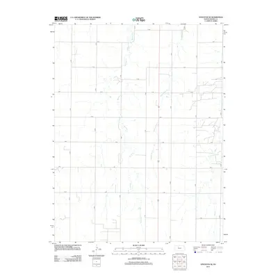
2012 Map of Stockton SE
USGS Topo · Published 2012About this map
Boxelder Creek and Roberts Roost Creek carve through the agricultural heart of southeastern Rooks County, following a north-south drainage pattern toward the Solomon River valley just beyond these borders. This 2012 survey reveals a landscape defined by the Public Land Survey System, where a rigid grid of rural roads—such as N Terrace and P Terrace—interfaces with the wandering paths of prairie streams. The area is characterized by sparse development, with a transportation network primarily composed of section-line roads like 18 Road and 20 Road. On the eastern edge, Elm Creek adds further topographic variety to this quiet pocket of the Great Plains, illustrating the enduring nature of Kansas township and range organization into the twenty-first century.
Find a feature on this map
20 named features on this map. Tap any name to fly to it.
Don’t see what you’re looking for? This feature index may not catch every label — zoom into the map to look around manually.
Map Details
Editions of this 2012 Stockton SE Map
This is the sole edition of this map. No revisions or reprints were ever made.
Other maps of this area

1896 · Plainville
USGS Topo · 1:125,000

1952 · Webster Dam
USGS Topo · 1:24,000

1953 · Woodston NW
USGS Topo · 1:24,000

1953 · Stockton
USGS Topo · 1:24,000

1955 · Beloit
USGS Topo · 1:250,000

1959 · Beloit
USGS Topo · 1:250,000

1969 · Stockton SW
USGS Topo · 1:24,000

1978 · Plainville
USGS Topo · 1:24,000
1978 · Codell
USGS Topo · 1:24,000
1978 · Twin Mound
USGS Topo · 1:24,000