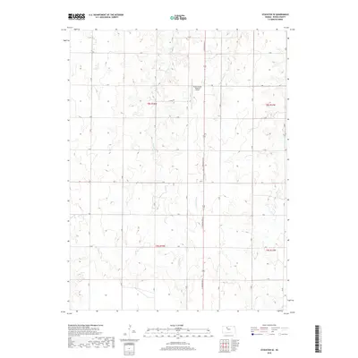
2018 Map of Stockton SE
USGS Topo · Published 2018About this map
Rooks County Regional Airport anchors the northern portion of this high-plains landscape, situated along N Washington St. The terrain is defined by the dendritic drainage patterns of intermittent waterways, including Boxelder Cr and Roberts Roost Cr which flow across the central sections, and Elm Cr in the east. This 2018 survey illustrates the systematic section-line road grid typical of western Kansas, marked by thoroughfares such as O Rd, P Rd, and S Rd. The map provides a detailed view of the rural infrastructure and land divisions within townships t8s r18w and t9s r17w, capturing the open agricultural character and watershed management of Rooks County in the early twenty-first century.
Find a feature on this map
18 named features on this map. Tap any name to fly to it.
Don’t see what you’re looking for? This feature index may not catch every label — zoom into the map to look around manually.
Map Details
Editions of this 2018 Stockton SE Map
This is the sole edition of this map. No revisions or reprints were ever made.
Other maps of this area

1896 · Plainville
USGS Topo · 1:125,000

1952 · Webster Dam
USGS Topo · 1:24,000

1953 · Woodston NW
USGS Topo · 1:24,000

1953 · Stockton
USGS Topo · 1:24,000

1955 · Beloit
USGS Topo · 1:250,000

1959 · Beloit
USGS Topo · 1:250,000

1969 · Stockton SW
USGS Topo · 1:24,000

1978 · Plainville
USGS Topo · 1:24,000
1978 · Codell
USGS Topo · 1:24,000
1978 · Twin Mound
USGS Topo · 1:24,000