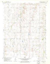
1978 Map of Stockton SE
USGS Topo · Published 1979About this map
The Oil Field operations of Rooks County dominate this central Kansas landscape, where numerous wells and access roads dot the sections south of the Stockton Municipal Airport. The terrain is defined by the drainage basins of Bow Creek and Robbers Roost Creek, which carve a network of draws and ridges through the high plains. This 1970s survey highlights the industrial footprint of the era, from the scattered Gravel Pit and Shale Pit excavations used for road maintenance to the more recreational presence of the County Country Club. The map provides a precise view of the rural infrastructure during a period of active resource extraction, showing the intersection of agriculture and energy in the township divisions.
Find a feature on this map
13 named features on this map. Tap any name to fly to it.
Don’t see what you’re looking for? This feature index may not catch every label — zoom into the map to look around manually.
Map Details
Editions of this 1978 Stockton SE Map
This is the sole edition of this map. No revisions or reprints were ever made.
Other maps of this area

1896 · Plainville
USGS Topo · 1:125,000

1952 · Webster Dam
USGS Topo · 1:24,000

1953 · Woodston NW
USGS Topo · 1:24,000

1953 · Stockton
USGS Topo · 1:24,000

1955 · Beloit
USGS Topo · 1:250,000

1959 · Beloit
USGS Topo · 1:250,000

1969 · Stockton SW
USGS Topo · 1:24,000

1978 · Plainville
USGS Topo · 1:24,000
1978 · Codell
USGS Topo · 1:24,000
1978 · Twin Mound
USGS Topo · 1:24,000