
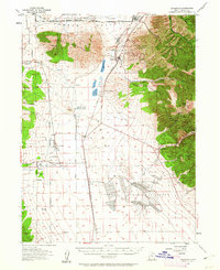
1955 Map of Stockton
USGS Topo · Published 1957About this map
The industrial and mining heritage of the Oquirrh Mountains is clearly etched across this mid-century landscape. To the east, the steep canyons are punctuated by historic mining operations such as the Shooting Star Mine, Hidden Treasure Mine, and Buffalo Mine. The high-altitude settlement of Ophir remains a focal point of this district, while the footprint of West Mercur appears at the southern edge of the mountains.
Find a feature on this map
63 named features on this map. Tap any name to fly to it.
Don’t see what you’re looking for? This feature index may not catch every label — zoom into the map to look around manually.
Map Details
Editions of this 1955 Stockton Map
2 editions found
Other maps of this area

1885 · Tooele Valley
USGS Topo · 1:250,000

1915 · Fairfield
USGS Topo · 1:62,500

1917 · Fairfield
USGS Topo · 1:62,500

1918 · Stockton
USGS Topo · 1:62,500

1947 · Fivemile Pass
USGS Topo · 1:62,500

1949 · Fivemile Pass
USGS Topo · 1:24,000

1952 · Bingham Canyon
USGS Topo · 1:24,000

1953 · Tooele
USGS Topo · 1:250,000

1955 · Timpie
USGS Topo · 1:62,500

1955 · Deseret Peak
USGS Topo · 1:62,500