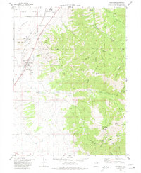
1980 Map of Stockton
USGS Topo · Published 1980About this map
The Union Pacific rail line cuts across the Tooele Valley in this survey of the northern Oquirrh Mountains. The settlement of Stockton serves as a hub between the industrial activity of the Tooele Army Depot to the north and the extensive mining operations to the south. The landscape is defined by deep drainages like Soldier Canyon and Settlement Canyon, which supported a complex network of extraction sites. High in the mountains, the map details established mining claims including the Hidden Treasure Mine and Queen of the Hills Mine near the vanished settlement of Gisborn. The presence of several Gravel Pits and a Tailings Pond near Bauer illustrates the heavy processing footprint of the era, while high-altitude landmarks like Sharp Mountain and Edwards Pass provided critical navigation points for mineral exploration.
Find a feature on this map
50 named features on this map. Tap any name to fly to it.
Don’t see what you’re looking for? This feature index may not catch every label — zoom into the map to look around manually.
Map Details
Editions of this 1980 Stockton Map
2 editions found
Other maps of this area

1885 · Tooele Valley
USGS Topo · 1:250,000

1915 · Fairfield
USGS Topo · 1:62,500

1917 · Fairfield
USGS Topo · 1:62,500

1918 · Stockton
USGS Topo · 1:62,500

1952 · Bingham Canyon
USGS Topo · 1:24,000

1953 · Tooele
USGS Topo · 1:250,000

1955 · Grantsville
USGS Topo · 1:24,000

1955 · Stockton
USGS Topo · 1:62,500

1955 · Tooele
USGS Topo · 1:250,000

1955 · Tooele
USGS Topo · 1:24,000