1965 Map of Stoddard
USGS Topo · Published 1968About this map
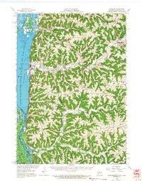
Coon Valley and Stoddard anchor this mid-1960s survey of the deeply dissected coulee country along the Wisconsin-Minnesota border. The Mississippi River dominates the western edge, defined by the extensive Upper Mississippi River Wild Life and Fish Refuge and a complex network of sloughs like Wigwam Slough and Quincy Slough. The intricate ridge-and-valley topography is marked by family and community landmarks, from Brinkman Ridge to Nottingham Ridge.
Find a feature on this map
115 named features on this map. Tap any name to fly to it.
Don’t see what you’re looking for? This feature index may not catch every label — zoom into the map to look around manually.
Map Details
Editions of this 1965 Stoddard Map
This is the sole edition of this map. No revisions or reprints were ever made.
Other maps of this area

1903 · Waukon
USGS Topo · 1:125,000

1909 · Sparta
USGS Topo · 1:62,500

1923 · Viroqua
USGS Topo · 1:62,500

1924 · Gays Mills
USGS Topo · 1:62,500

1926 · Gays Mills
USGS Topo · 1:62,500

1926 · Stoddard
USGS Topo · 1:62,500

1926 · Viroqua
USGS Topo · 1:62,500

1927 · La Crosse
USGS Topo · 1:62,500

1929 · Ferryville
USGS Topo · 1:62,500

1930 · La Crescent
USGS Topo · 1:62,500