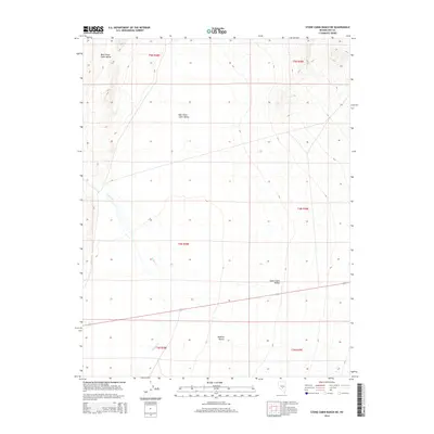
2014 Map of Stone Cabin Ranch NE
USGS Topo · Published 2014About this map
Stone Cabin Valley dominates this high-elevation desert landscape, where the shifting drainage patterns of the Ralston Desert meet the northern reaches of the basin. The map illustrates a transitional arid environment defined by seasonal hydrology, most notably the intermittent flow of Willow Creek, which descends from the western slopes into the broad alluvial plains. The topography is divided into distinct local geographic segments including West Stone Cabin Valley and East Stone Cabin Valley, highlighting the subtle ridge-and-basin structure that characterizes this part of Nevada. Aside from several primitive roads and the Public Land Survey System grid, the land remains largely open, reflecting a modern period of minimal development and preservation of the natural Great Basin character.
Find a feature on this map
11 named features on this map. Tap any name to fly to it.
Don’t see what you’re looking for? This feature index may not catch every label — zoom into the map to look around manually.
Map Details
Editions of this 2014 Stone Cabin Ranch NE Map
This is the sole edition of this map. No revisions or reprints were ever made.
Other maps of this area

1956 · Tonopah
USGS Topo · 1:250,000

1959 · Tonopah
USGS Topo · 1:250,000

1962 · Tonopah
USGS Topo · 1:250,000

1968 · Tybo
USGS Topo · 1:62,500

1968 · Warm Springs
USGS Topo · 1:62,500
1968 · Warm Springs NW
USGS Topo · 1:24,000
1968 · Bellehelen
USGS Topo · 1:24,000
1968 · Tybo
USGS Topo · 1:24,000
1971 · Georges Canyon Rim SE
USGS Topo · 1:24,000
1971 · Georges Canyon Rim
USGS Topo · 1:24,000