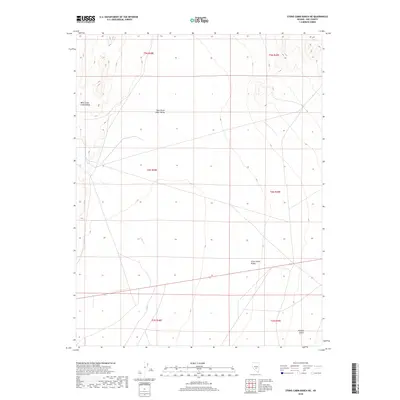
2018 Map of Stone Cabin Ranch NE
USGS Topo · Published 2018About this map
Stone Cabin Valley dominates this high-elevation portion of Nye County, where the landscape is defined by its vast basin floor and subtle drainage patterns. The valley is geographically divided on the map between West Stone Cabin Valley and East Stone Cabin Valley, illustrating a topography of significant basins separated by low rises. Willow Cr provides the primary hydrological detail for the area, threading through the central and southern portions of the sheet as it moves toward the Ralston Desert to the southeast. The survey demonstrates the grid-like partitioning of these desert lands into townships such as t4n r48e and t5n r49e, reflecting the administrative organization of the Nevada interior during the early 21st century.
Find a feature on this map
11 named features on this map. Tap any name to fly to it.
Don’t see what you’re looking for? This feature index may not catch every label — zoom into the map to look around manually.
Map Details
Editions of this 2018 Stone Cabin Ranch NE Map
This is the sole edition of this map. No revisions or reprints were ever made.
Other maps of this area

1956 · Tonopah
USGS Topo · 1:250,000

1959 · Tonopah
USGS Topo · 1:250,000

1962 · Tonopah
USGS Topo · 1:250,000

1968 · Tybo
USGS Topo · 1:62,500

1968 · Warm Springs
USGS Topo · 1:62,500
1968 · Warm Springs NW
USGS Topo · 1:24,000
1968 · Bellehelen
USGS Topo · 1:24,000
1968 · Tybo
USGS Topo · 1:24,000
1971 · Georges Canyon Rim SE
USGS Topo · 1:24,000
1971 · Georges Canyon Rim
USGS Topo · 1:24,000