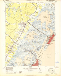
1944 Map of Stone Harbor
USGS Topo · Published 1944About this map
The county seat at Cape May Court House serves as the inland anchor for this coastal survey, which documents the intricate tidal landscape of New Jersey's Atlantic shoreline during the mid-1940s. The mainland is connected to the barrier islands by the Stone Harbor Blvd and the Pennsylvania Reading Seashore Lines, which traverse a complex network of wetlands including Mulford Creek Meadow and Great Flat. The map reveals the early development of Stone Harbor and North Wildwood, where organized street grids contrast sharply with the natural erraticism of the surrounding marshlands and sounds.
Find a feature on this map
186 named features on this map. Tap any name to fly to it.
Don’t see what you’re looking for? This feature index may not catch every label — zoom into the map to look around manually.
Map Details
Editions of this 1944 Stone Harbor Map
3 editions found
Other maps of this area

1884 · Sea Isle
USGS Topo · 1:62,500

1888 · Cape May
USGS Topo · 1:62,500

1888 · Dennisville
USGS Topo · 1:62,500

1888 · Sea Isle
USGS Topo · 1:62,500

1893 · Cape May
USGS Topo · 1:62,500

1894 · Dennisville
USGS Topo · 1:62,500

1894 · Sea Isle
USGS Topo · 1:62,500

1898 · Cape May
USGS Topo · 1:62,500

1918 · Cape May
USGS Topo · 1:62,500

1919 · Sea Isle
USGS Topo · 1:62,500