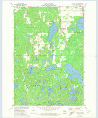
1971 Map of Stone Lake
USGS Topo · Published 1974About this map
Glacial lakes and wetlands define this portion of the Wisconsin Northwoods in the early 1970s. The unincorporated community of Stone Lake serves as the primary settlement, situated along the Soo Line railroad. Local infrastructure is sparse, characterized by a Townhall, the Evergreen Cem, and a network of secondary roads including a designated Fire Lane. The landscape is heavily influenced by water management and natural resources, evidenced by Cranberry Bogs near Spring Lake and several Gravel Pits scattered across the township.
Find a feature on this map
51 named features on this map. Tap any name to fly to it.
Don’t see what you’re looking for? This feature index may not catch every label — zoom into the map to look around manually.
Map Details
Editions of this 1971 Stone Lake Map
This is the sole edition of this map. No revisions or reprints were ever made.
Other maps of this area

1944 · Couderay
USGS Topo · 1:48,000

1945 · Meteor
USGS Topo · 1:48,000

1948 · Couderay
USGS Topo · 1:48,000

1948 · Stone Lake
USGS Topo · 1:48,000

1949 · Meteor
USGS Topo · 1:48,000

1949 · Rice Lake
USGS Topo · 1:48,000

1950 · Stone Lake
USGS Topo · 1:48,000

1951 · Rice Lake
USGS Topo · 1:48,000

1953 · Rice Lake
USGS Topo · 1:250,000

1959 · Rice Lake
USGS Topo · 1:250,000