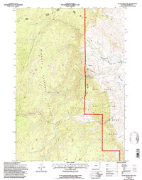
1993 Map of Stone Mountain
USGS Topo · Published 1997About this map
Bighorn National Forest dominates this landscape on the border of Johnson County, where complex water management infrastructure meets steep Wyoming terrain. Irrigation efforts are evident in the Tongue River Buffalo Ditch, Crow Ditch, and Mowry Basin Ditch, which redirect high-elevation snowmelt. The eastern slopes descend toward the Bud Love Big Game Winter Range, a significant conservation area established to protect wildlife habitat.
Find a feature on this map
36 named features on this map. Tap any name to fly to it.
Don’t see what you’re looking for? This feature index may not catch every label — zoom into the map to look around manually.
Map Details
Editions of this 1993 Stone Mountain Map
This is the sole edition of this map. No revisions or reprints were ever made.
Other maps of this area

1895 · Dayton
USGS Topo · 1:125,000

1899 · Cloud peak
USGS Topo · 1:125,000

1900 · Fort McKinney
USGS Topo · 1:125,000

1901 · Cloud Peak
USGS Topo · 1:125,000

1901 · Dayton
USGS Topo · 1:125,000

1903 · Fort McKinney
USGS Topo · 1:125,000

1909 · Sheridan
USGS Topo · 1:125,000

1911 · Sheridan
USGS Topo · 1:125,000

1955 · Sheridan
USGS Topo · 1:250,000

1958 · Sheridan
USGS Topo · 1:250,000