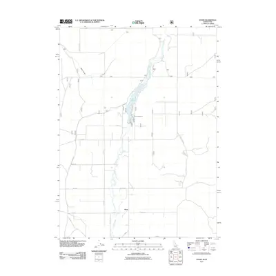
2011 Map of Stone
USGS Topo · Published 2011About this map
Stone serves as the primary settlement hub in this rural Oneida County landscape, situated near the Idaho-Utah border. The geography is defined by the winding course of Deep Creek, which flows through the center of the quadrangle and feeds into the Stone Reservoir. This water system supports a network of agricultural roads and residential plots that follow a strict grid, punctuated by landmarks such as the Curlew Campground located along the eastern shore of the reservoir. To the northwest, the terrain shifts as it approaches North Canyon, where North Canyon Rd provides access into the rising elevations. The map reveals a community structured around water and transport, with family-named or utilitarian routes like Mills Rd, Neal Scott Rd, and S North String Rd connecting the dispersed homesteads and fields.
Find a feature on this map
21 named features on this map. Tap any name to fly to it.
Don’t see what you’re looking for? This feature index may not catch every label — zoom into the map to look around manually.
Map Details
Editions of this 2011 Stone Map
This is the sole edition of this map. No revisions or reprints were ever made.
Other maps of this area

1954 · Pocatello
USGS Topo · 1:250,000

1954 · Brigham City
USGS Topo · 1:250,000

1958 · Pocatello
USGS Topo · 1:250,000

1958 · Brigham City
USGS Topo · 1:250,000

1962 · Brigham City
USGS Topo · 1:250,000

1968 · Rattlesnake Pass
USGS Topo · 1:24,000

1968 · Snowville
USGS Topo · 1:24,000

1968 · Monument Peak NE
USGS Topo · 1:24,000

1973 · The Cove
USGS Topo · 1:24,000
1973 · Stone
USGS Topo · 1:24,000