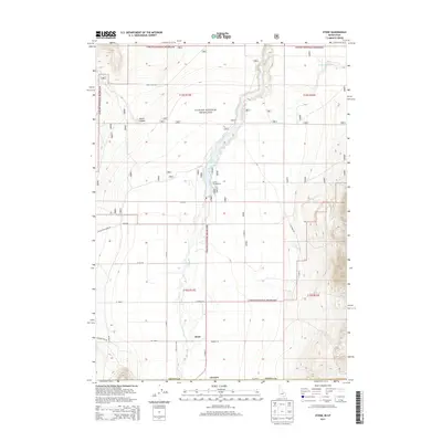
2013 Map of Stone
USGS Topo · Published 2013About this map
Stone sits at the heart of this high-desert basin near the Idaho-Utah border, serving as a focal point for the surrounding agricultural and grazing lands. The settlement is positioned along the winding course of Deep Cr, which feeds into the Stone Reservoir to the north. Much of the landscape is dedicated to the Curlew National Grassland, a vast managed territory that reflects the region's historical transition from homesteading to federal land management. Evidence of recreational use is found at the Curlew Campground, while the remote character of the area is underscored by the grid of rural roads like Black Pine Stone Rd and S Neal Scott Rd. To the northeast, the Sweeten Reservoir and the drainage of North Canyon provide further detail on the hydrologic and topographic features of Oneida County.
Find a feature on this map
30 named features on this map. Tap any name to fly to it.
Don’t see what you’re looking for? This feature index may not catch every label — zoom into the map to look around manually.
Map Details
Editions of this 2013 Stone Map
This is the sole edition of this map. No revisions or reprints were ever made.
Other maps of this area

1954 · Pocatello
USGS Topo · 1:250,000

1954 · Brigham City
USGS Topo · 1:250,000

1958 · Pocatello
USGS Topo · 1:250,000

1958 · Brigham City
USGS Topo · 1:250,000

1962 · Brigham City
USGS Topo · 1:250,000

1968 · Rattlesnake Pass
USGS Topo · 1:24,000

1968 · Snowville
USGS Topo · 1:24,000

1968 · Monument Peak NE
USGS Topo · 1:24,000

1973 · The Cove
USGS Topo · 1:24,000
1973 · Stone
USGS Topo · 1:24,000