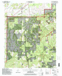
1996 Map of Stonefort
USGS Topo · Published 1998About this map
Stonefort and the adjacent Oldtown sit at the northern edge of this Southern Illinois landscape, where the flat agricultural fields of the north give way to the forested interior of the Shawnee National Forest. The map documents a dense network of rural life through the mid-1990s, anchored by numerous country churches such as Little Saline Ch and Olive Ch, and small cemeteries like Bolton Cem and Joyner Cem that reflect generations of local families.
Find a feature on this map
48 named features on this map. Tap any name to fly to it.
Don’t see what you’re looking for? This feature index may not catch every label — zoom into the map to look around manually.
Map Details
Editions of this 1996 Stonefort Map
This is the sole edition of this map. No revisions or reprints were ever made.
Other maps of this area

1917 · Brownfield
USGS Topo · 1:62,500

1918 · Vienna
USGS Topo · 1:62,500

1919 · Vienna
USGS Topo · 1:62,500

1925 · Marion
USGS Topo · 1:62,500

1925 · Harrisburg
USGS Topo · 1:62,500

1939 · Harrisburg
USGS Topo · 1:62,500

1940 · Marion
USGS Topo · 1:62,500

1942 · Vienna
USGS Topo · 1:62,500

1949 · Paducah
USGS Topo · 1:250,000

1950 · Paducah
USGS Topo · 1:250,000