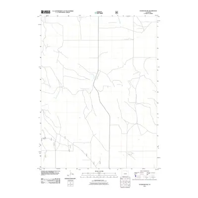
2011 Map of Stoneham NW
USGS Topo · Published 2011About this map
Pawnee Creek and its major tributaries define this high plains landscape in Weld County. This 2011 survey documents a sparsely settled ranching region characterized by intermittent watercourses like North Pawnee Creek and South Pawnee Creek, which converge as they flow across the terrain. A network of rural county roads, including Co RD 139 and Co RD 141, provides the primary infrastructure for the area, connecting isolated agricultural points. One of the most distinctive markers in this expansive environment is the Hole in the Wall Windmill, a local landmark that suggests the critical importance of groundwater for survival and industry on these plains. Farther north, the map shows Cottonwood Creek and Horsetail Creek cutting through the open land, illustrating the natural drainage patterns of this Colorado region before it reaches larger river systems.
Find a feature on this map
9 named features on this map. Tap any name to fly to it.
Don’t see what you’re looking for? This feature index may not catch every label — zoom into the map to look around manually.
Map Details
Editions of this 2011 Stoneham NW Map
This is the sole edition of this map. No revisions or reprints were ever made.
Other maps of this area

1954 · Sterling
USGS Topo · 1:250,000

1958 · Sterling
USGS Topo · 1:250,000
1977 · Gatehook Spring
USGS Topo · 1:24,000

1977 · Stoneham
USGS Topo · 1:24,000

1977 · Stoneham NE
USGS Topo · 1:24,000

1977 · Raymer NE
USGS Topo · 1:24,000

1977 · Avalo SE
USGS Topo · 1:24,000

1978 · Stoneham NW
USGS Topo · 1:24,000
1978 · Avalo
USGS Topo · 1:24,000
1978 · Raymer
USGS Topo · 1:24,000