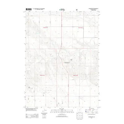
2013 Map of Stoneham NW
USGS Topo · Published 2013About this map
Pawnee National Grassland dominates this section of the High Plains, where the drainage patterns of North Pawnee Creek and South Pawnee Creek carve into the flat Weld County landscape. This 2013 survey illustrates the sparse, grid-based infrastructure of the region, anchored by State Hwy 71 running north-south through the center of the sheet. The terrain is characterized by broad valleys and intermittent watercourses, including the upper reaches of Cottonwood Creek and Pawnee Creek. Evidence of ranching and water management in this arid environment is highlighted by the Hole in the Wall Windmill, a specific landmark providing a focal point for researchers interested in local land use. The map also detail the extensive network of county roads, such as CO Road 102 and CO Road 141, which define the section lines of the township and range system.
Find a feature on this map
21 named features on this map. Tap any name to fly to it.
Don’t see what you’re looking for? This feature index may not catch every label — zoom into the map to look around manually.
Map Details
Editions of this 2013 Stoneham NW Map
This is the sole edition of this map. No revisions or reprints were ever made.
Other maps of this area

1954 · Sterling
USGS Topo · 1:250,000

1958 · Sterling
USGS Topo · 1:250,000
1977 · Gatehook Spring
USGS Topo · 1:24,000

1977 · Stoneham
USGS Topo · 1:24,000

1977 · Stoneham NE
USGS Topo · 1:24,000

1977 · Raymer NE
USGS Topo · 1:24,000

1977 · Avalo SE
USGS Topo · 1:24,000

1978 · Stoneham NW
USGS Topo · 1:24,000
1978 · Avalo
USGS Topo · 1:24,000
1978 · Raymer
USGS Topo · 1:24,000