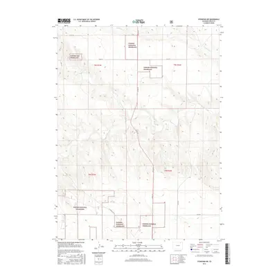
2016 Map of Stoneham NW
USGS Topo · Published 2016About this map
The Pawnee National Grassland dominates this section of Weld County, characterized by the intricate drainage networks of Pawnee Creek and its tributaries. The landscape is defined by the ephemeral flow of North Pawnee Creek and South Pawnee Creek, which carve through the high plains topography. This 2016 survey illustrates a modern management of the prairie, where established county routes like Co Rd 145 and Co Rd 102 provide access to the vast federal lands. The inclusion of the US Forrest Svc Rd highlights the intersection of local transit and Forest Service infrastructure in this rural Colorado corridor. Farther north, the presence of Cottonwood Creek provides a secondary focal point for the region's hydrology, marking the transition between different management blocks of the Pawnee Nat Grassland.
Find a feature on this map
19 named features on this map. Tap any name to fly to it.
Don’t see what you’re looking for? This feature index may not catch every label — zoom into the map to look around manually.
Map Details
Editions of this 2016 Stoneham NW Map
This is the sole edition of this map. No revisions or reprints were ever made.
Other maps of this area

1954 · Sterling
USGS Topo · 1:250,000

1958 · Sterling
USGS Topo · 1:250,000
1977 · Gatehook Spring
USGS Topo · 1:24,000

1977 · Stoneham
USGS Topo · 1:24,000

1977 · Stoneham NE
USGS Topo · 1:24,000

1977 · Raymer NE
USGS Topo · 1:24,000

1977 · Avalo SE
USGS Topo · 1:24,000

1978 · Stoneham NW
USGS Topo · 1:24,000
1978 · Avalo
USGS Topo · 1:24,000
1978 · Raymer
USGS Topo · 1:24,000