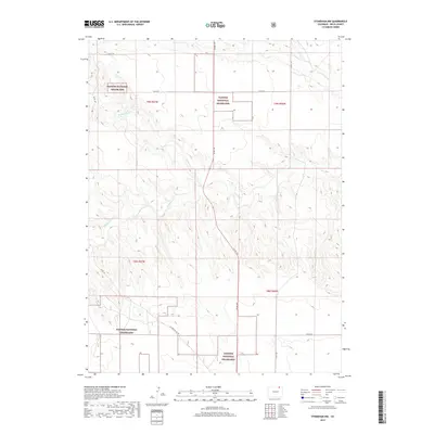
2019 Map of Stoneham NW
USGS Topo · Published 2019About this map
Pawnee National Grassland dominates this high plains landscape in Weld County, where a network of seasonal watercourses like Cottonwood Cr and N Pawnee Cr carve through the open terrain. This 2019 survey illustrates the organized township and range system that continues to define land management in the West, specifically within the boundaries of t9n r57w and t8n r56w. The transition from the more established Co Rd 102 and Co Rd 145 to the more specialized US Forrest Svc Rd reflects the integration of public grazing lands with rural county infrastructure. Researchers of Colorado’s prairie history can trace the convergence of S Pawnee Cr and Pawnee Cr as they flow through these protected grasslands, providing a detailed look at the hydrology and road networks of the northeastern plains.
Find a feature on this map
18 named features on this map. Tap any name to fly to it.
Don’t see what you’re looking for? This feature index may not catch every label — zoom into the map to look around manually.
Map Details
Editions of this 2019 Stoneham NW Map
This is the sole edition of this map. No revisions or reprints were ever made.
Other maps of this area

1954 · Sterling
USGS Topo · 1:250,000

1958 · Sterling
USGS Topo · 1:250,000
1977 · Gatehook Spring
USGS Topo · 1:24,000

1977 · Stoneham
USGS Topo · 1:24,000

1977 · Stoneham NE
USGS Topo · 1:24,000

1977 · Raymer NE
USGS Topo · 1:24,000

1977 · Avalo SE
USGS Topo · 1:24,000

1978 · Stoneham NW
USGS Topo · 1:24,000
1978 · Avalo
USGS Topo · 1:24,000
1978 · Raymer
USGS Topo · 1:24,000