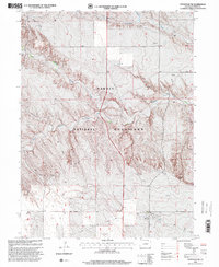
1997 Map of Stoneham NW
USGS Topo · Published 2000About this map
Pawnee National Grassland dominates this portion of Weld County, defining a landscape of complex drainages and prairie infrastructure. The topographical relief is shaped by the intermittent flow of South Pawnee Creek, which winds through the southern and central sections, while Cottonwood Creek and Horsetail Creek cut across the northern reaches. This 1997 revision reflects the region’s persistent reliance on resource extraction and water management, evidenced by numerous scattered Oil Wells and a Gravel Pit. The mapping of subterranean utility corridors, marked by an extensive network of Pipelines and Cables, suggests a landscape deeply integrated into regional energy and telecommunications networks despite its open appearance. Researchers can trace the placement of vital livestock and industrial resources through the recurring locations of Water Tanks and Wells distributed across the high plains.
Find a feature on this map
13 named features on this map. Tap any name to fly to it.
Don’t see what you’re looking for? This feature index may not catch every label — zoom into the map to look around manually.
Map Details
Editions of this 1997 Stoneham NW Map
This is the sole edition of this map. No revisions or reprints were ever made.
Other maps of this area

1954 · Sterling
USGS Topo · 1:250,000

1958 · Sterling
USGS Topo · 1:250,000
1977 · Gatehook Spring
USGS Topo · 1:24,000

1977 · Stoneham
USGS Topo · 1:24,000

1977 · Stoneham NE
USGS Topo · 1:24,000

1977 · Raymer NE
USGS Topo · 1:24,000

1977 · Avalo SE
USGS Topo · 1:24,000

1978 · Stoneham NW
USGS Topo · 1:24,000
1978 · Avalo
USGS Topo · 1:24,000
1978 · Raymer
USGS Topo · 1:24,000