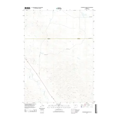
2014 Map of Stonehouse Ranch SW
USGS Topo · Published 2014About this map
The Calamus River meanders through the southwestern corner of this landscape, carving a distinct riparian corridor through the characteristic sandhills of central Nebraska. This 2014 survey captures a sparsely populated region where the environment is defined by expansive terrain like Gracie Flats and the winding course of the river. The road network is primarily composed of section-line roads such as 450th Ave and 842nd Rd, which provide access to the remote ranchlands that dominate the area. The passage of Us-183 across the river valley serves as the primary transportation artery, connecting the high plains to the north with the river basins to the south. The boundary between Rock and Loup counties is clearly delineated, marking a significant administrative divide in this rural ranching country where Gracie Creek Ave serves as a local connector between distant property holdings.
Find a feature on this map
8 named features on this map. Tap any name to fly to it.
Don’t see what you’re looking for? This feature index may not catch every label — zoom into the map to look around manually.
Map Details
Editions of this 2014 Stonehouse Ranch SW Map
This is the sole edition of this map. No revisions or reprints were ever made.
Other maps of this area

1952 · Taylor NW
USGS Topo · 1:24,000

1952 · Almeria NE
USGS Topo · 1:24,000

1952 · Taylor NE
USGS Topo · 1:24,000

1955 · Broken Bow
USGS Topo · 1:250,000

1955 · O'Neill
USGS Topo · 1:250,000

1956 · Broken Bow
USGS Topo · 1:250,000

1959 · O'Neill
USGS Topo · 1:250,000

1969 · O'Neill
USGS Topo · 1:250,000

1981 · Stonehouse Ranch NW
USGS Topo · 1:24,000

1981 · Stonehouse Ranch NE
USGS Topo · 1:24,000