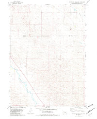
1981 Map of Stonehouse Ranch SW
USGS Topo · Published 1982About this map
The Calamus River winds through the southwestern corner of this Nebraska landscape, cutting a distinct path across a terrain dominated by the complex dune-like formations of the Sandhills. In the early 1980s, the economic life of this region remained centered on large-scale ranching operations, represented here by named holdings such as the C 7 Ranch in the northeast and the Lazy R Ranch further south.
Find a feature on this map
9 named features on this map. Tap any name to fly to it.
Don’t see what you’re looking for? This feature index may not catch every label — zoom into the map to look around manually.
Map Details
Editions of this 1981 Stonehouse Ranch SW Map
This is the sole edition of this map. No revisions or reprints were ever made.
Other maps of this area

1952 · Taylor NW
USGS Topo · 1:24,000

1952 · Almeria NE
USGS Topo · 1:24,000

1952 · Taylor NE
USGS Topo · 1:24,000

1955 · Broken Bow
USGS Topo · 1:250,000

1955 · O'Neill
USGS Topo · 1:250,000

1956 · Broken Bow
USGS Topo · 1:250,000

1959 · O'Neill
USGS Topo · 1:250,000

1969 · O'Neill
USGS Topo · 1:250,000

1981 · Stonehouse Ranch NW
USGS Topo · 1:24,000

1981 · Stonehouse Ranch NE
USGS Topo · 1:24,000