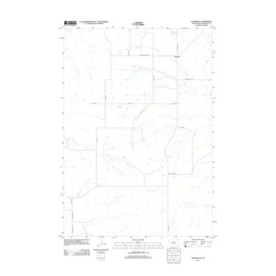
2012 Map of Stoneville
USGS Topo · Published 2012About this map
Stoneville serves as the primary landmark in this remote corner of Meade County, where the plains are defined by an intricate network of seasonal drainage and long rural reaches. The landscape is carved by several prominent waterways, including Cherry Cr in the north and the winding White Owl Cr to the south. This 2012 survey illustrates the enduring grid of the high plains, where travel relies on a mixture of established routes like Chalk Butte Rd and localized thoroughfares such as Indian Creek Rd. Local history is embedded in the road names themselves, with Old Stoneville Rd tracing the earlier movement patterns of the region. The map also captures several smaller tributaries, such as Coyote Cr and Indian Cr, which dictate the placement of ranch access roads like Onion Pl and Nova Pl.
Find a feature on this map
21 named features on this map. Tap any name to fly to it.
Don’t see what you’re looking for? This feature index may not catch every label — zoom into the map to look around manually.
Map Details
Editions of this 2012 Stoneville Map
This is the sole edition of this map. No revisions or reprints were ever made.
Other maps of this area

1953 · Rapid City
USGS Topo · 1:250,000

1957 · Rapid City
USGS Topo · 1:250,000

1959 · Fairpoint
USGS Topo · 1:24,000

1959 · Enning
USGS Topo · 1:24,000

1959 · Redowl
USGS Topo · 1:24,000

1959 · Stoneville
USGS Topo · 1:24,000

1959 · Union Center
USGS Topo · 1:24,000
1959 · Fairpoint SE
USGS Topo · 1:24,000

1978 · Bull Run Creek
USGS Topo · 1:24,000

1983 · Opal West SE
USGS Topo · 1:24,000