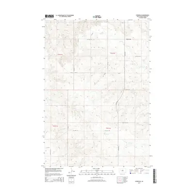
2015 Map of Stoneville
USGS Topo · Published 2015About this map
Stoneville serves as the focal point of this South Dakota landscape, situated at the intersection of Stoneville Rd and Old Stoneville Rd. The area is defined by an extensive drainage system of prairie creeks, most notably Red Owl Cr and White Owl Cr, which carve through the terrain of Meade County. The map provides a detailed view of the Public Land Survey System divisions, specifically within the townships of t9n r11e, t9n r12e, t8n r11e, and t8n r12e. Local transit is marked by a grid of rural routes including Indian Creek Rd, Chalk Butte Rd, and Atall Rd, reflecting the sparse but organized settlement patterns characteristic of the High Plains. The drainage patterns of Coyote Cr and Indian Cr further illustrate the topographic complexity of this cattle-country region.
Find a feature on this map
22 named features on this map. Tap any name to fly to it.
Don’t see what you’re looking for? This feature index may not catch every label — zoom into the map to look around manually.
Map Details
Editions of this 2015 Stoneville Map
This is the sole edition of this map. No revisions or reprints were ever made.
Other maps of this area

1953 · Rapid City
USGS Topo · 1:250,000

1957 · Rapid City
USGS Topo · 1:250,000

1959 · Fairpoint
USGS Topo · 1:24,000

1959 · Enning
USGS Topo · 1:24,000

1959 · Redowl
USGS Topo · 1:24,000

1959 · Stoneville
USGS Topo · 1:24,000

1959 · Union Center
USGS Topo · 1:24,000
1959 · Fairpoint SE
USGS Topo · 1:24,000

1978 · Bull Run Creek
USGS Topo · 1:24,000

1983 · Opal West SE
USGS Topo · 1:24,000