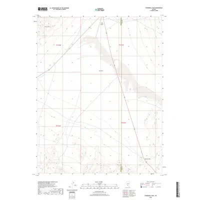
2018 Map of Stonewall Pass
USGS Topo · Published 2018About this map
Lida Valley serves as the central drainage for this high-desert landscape on the border of Nye and Esmeralda counties. The terrain is defined by the stark transition from the alluvial fans of the valley floor to the rising elevations of the Cuprite Hills in the northwest and the prominent Stonewall Pass in the southeast. Transportation and infrastructure are concentrated along the north-south highway corridor, where the Lida Junction Airport stands as a lonely landmark in the basin. The map illustrates a classic Great Basin drainage pattern, with ephemeral features like Jackson Wash cutting through the arid landscape toward the lower elevations of the valley. This 2018 survey provides a clear view of the complex topography and the sparse human footprint within these remote basin-and-range public lands.
Find a feature on this map
10 named features on this map. Tap any name to fly to it.
Don’t see what you’re looking for? This feature index may not catch every label — zoom into the map to look around manually.
Map Details
Editions of this 2018 Stonewall Pass Map
This is the sole edition of this map. No revisions or reprints were ever made.
Other maps of this area

1908 · Lida
USGS Topo · 1:250,000

1913 · Lida
USGS Topo · 1:250,000

1945 · Goldfield
USGS Topo · 1:125,000

1952 · Goldfield
USGS Topo · 1:62,500

1954 · Goldfield
USGS Topo · 1:250,000

1955 · Goldfield
USGS Topo · 1:250,000

1958 · Goldfield
USGS Topo · 1:250,000

1962 · Goldfield
USGS Topo · 1:250,000

1968 · Stonewall Pass
USGS Topo · 1:24,000
1968 · Gold Point
USGS Topo · 1:24,000