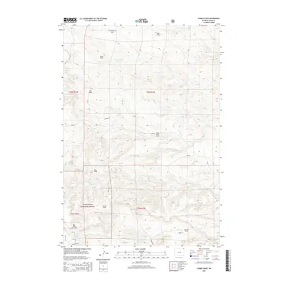
2015 Map of Stoney Point
USGS Topo · Published 2015About this map
The Bear Lodge Mountains dominate this high-plains landscape within the western edge of the Black Hills National Forest. This 2015 survey reveals a terrain defined by deep drainages and ridges, where named features like Windy Point and Blue Ridge overlook a network of seasonal watercourses. The presence of Christofferson Dam in the north and the North Fork Pine Creek Spring in the south illustrates the critical role of water management in this arid Crook County environment. Transportation through the area is limited to a few key routes such as Mona Rd and Pine Creek Rd, which navigate between the high points of Stoney Point and the complex gullies of Three Bear Gulch and Pearson Draw. This map serves as an essential record of the contemporary infrastructure and natural landmarks within this sparsely populated segment of Wyoming.
Find a feature on this map
28 named features on this map. Tap any name to fly to it.
Don’t see what you’re looking for? This feature index may not catch every label — zoom into the map to look around manually.
Map Details
Editions of this 2015 Stoney Point Map
This is the sole edition of this map. No revisions or reprints were ever made.
Other maps of this area

1901 · Aladdin
USGS Topo · 1:125,000

1903 · Aladdin
USGS Topo · 1:125,000

1954 · Gillette
USGS Topo · 1:250,000

1955 · Gillette
USGS Topo · 1:250,000

1957 · Mona
USGS Topo · 1:62,500

1957 · Colony
USGS Topo · 1:62,500

1958 · Gillette
USGS Topo · 1:250,000

1958 · Beulah
USGS Topo · 1:62,500

1962 · Gillette
USGS Topo · 1:250,000
1979 · Devils Tower
USGS Topo · 1:100,000