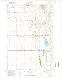
1973 Map of Stony Lake
USGS Topo · Published 1975About this map
Lawrence and North Ottawa townships define this agricultural and wetland landscape in the early 1970s, where the Rabbit River meanders through prairie terrain along the border of Otter Tail and Grant counties. The area is heavily managed for conservation, as seen in the expansive National Waterfowl Production Area and several state-managed tracts including the Copeland State Wildlife Management Area and Shuck State Wildlife Management Area. Transport and industry are marked by the active Soo Line and a long Old Railroad Grade that cuts across the southern landscape. For local history, the map preserves the location of the Lawrence Ch and Hereford Cem, along with numerous gravel pits that speak to the region's glacial geology and local infrastructure needs.
Find a feature on this map
22 named features on this map. Tap any name to fly to it.
Don’t see what you’re looking for? This feature index may not catch every label — zoom into the map to look around manually.
Map Details
Editions of this 1973 Stony Lake Map
This is the sole edition of this map. No revisions or reprints were ever made.
Other maps of this area

1910 · Wendell
USGS Topo · 1:62,500

1911 · Herman
USGS Topo · 1:62,500

1913 · Wendell
USGS Topo · 1:62,500

1951 · Wheaton
USGS Topo · 1:62,500

1951 · Campbell
USGS Topo · 1:62,500

1953 · Milbank
USGS Topo · 1:250,000

1953 · Fargo
USGS Topo · 1:250,000

1956 · Fargo
USGS Topo · 1:250,000

1958 · Milbank
USGS Topo · 1:250,000

1973 · Herman NW
USGS Topo · 1:24,000