1929 Map of Stony Man
USGS Topo · Published 1962About this map
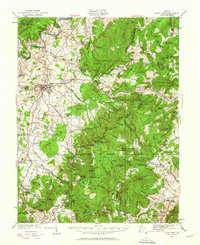
Luray sits at the heart of this late 1920s survey, marking a transition between the productive valley and the towering peaks of the Blue Ridge. The town's significance as a destination is underscored by the famous Luray Caverns and the Panorama Hotel, while the Norfolk and Western railway links it to larger markets. Higher in the mountains, early recreation and tourism are evident at Skyland, situated near the peak of Stony Man.
Find a feature on this map
154 named features on this map. Tap any name to fly to it.
Don’t see what you’re looking for? This feature index may not catch every label — zoom into the map to look around manually.
Map Details
Editions of this 1929 Stony Man Map
2 editions found
Other maps of this area

1892 · Woodstock
USGS Topo · 1:125,000

1892 · Gordonsville
USGS Topo · 1:125,000

1892 · Harrisonburg
USGS Topo · 1:125,000

1893 · Luray
USGS Topo · 1:125,000

1905 · Luray
USGS Topo · 1:125,000

1923 · Edinburg
USGS Topo · 1:62,500

1929 · Stony Man
USGS Topo · 1:48,000

1930 · Madison
USGS Topo · 1:48,000

1933 · Stony Man
USGS Topo · 1:62,500

1933 · Madison
USGS Topo · 1:62,500