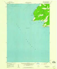
1958 Map of Stony Point
USGS Topo · Published 1960About this map
Stony Point dominates this 1958 survey, extending into the eastern waters of Lake Ontario where the townships of Hounsfield and Henderson meet. The maritime character of the Jefferson County shoreline is clearly defined by several indentations including Gravely Bay, Boomer Cove, and Ray Bay. A prominent Lighthouse stands as a navigational landmark on the point's western edge, connected to the interior by a small network of rural routes such as Lighthouse Road and Military Road. This map reflects a mid-century coastal landscape largely defined by its natural topography and seasonal access, including the outlying Calf Island and the protected waters of Sawyer Bay. The detailed hydrography, compiled from earlier Lake Survey charts, provides a precise look at the underwater shelf and soundings surrounding Clark Point.
Find a feature on this map
21 named features on this map. Tap any name to fly to it.
Don’t see what you’re looking for? This feature index may not catch every label — zoom into the map to look around manually.
Map Details
Editions of this 1958 Stony Point Map
2 editions found
Other maps of this area

1893 · Sackets Harbor
USGS Topo · 1:62,500

1895 · Sacketts Harbor
USGS Topo · 1:62,500

1895 · Stony Island
USGS Topo · 1:62,500

1895 · Pulaski
USGS Topo · 1:62,500

1942 · Stony Point
USGS Topo · 1:31,680

1942 · Henderson Bay
USGS Topo · 1:31,680

1942 · Galloo Island
USGS Topo · 1:31,680

1942 · Point Peninsula
USGS Topo · 1:31,680

1943 · Henderson
USGS Topo · 1:31,680
1943 · Ellisburg
USGS Topo · 1:31,680