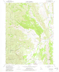
1968 Map of Stonyford
USGS Topo · Published 1982About this map
Stonyford sits at the southern edge of this 1968 landscape, serving as a gateway to the diverse terrain of the Mendocino National Forest. The geography is defined by a series of prominent ridges, including Gravelly Ridge, Green Valley Ridge, and the distinctive Black Diamond Ridge. These elevations are cut by significant waterways like Stony Creek and Little Stony Creek, which helped shape the grazing and small-scale mining activity of the area.
Find a feature on this map
31 named features on this map. Tap any name to fly to it.
Don’t see what you’re looking for? This feature index may not catch every label — zoom into the map to look around manually.
Map Details
Editions of this 1968 Stonyford Map
3 editions found
Other maps of this area

1919 · Fruto
USGS Topo · 1:62,500

1919 · Elk Creek
USGS Topo · 1:62,500

1943 · Lodoga
USGS Topo · 1:62,500

1944 · Fruto
USGS Topo · 1:62,500

1948 · Elk Creek
USGS Topo · 1:62,500

1951 · Stonyford
USGS Topo · 1:62,500

1957 · Elk Creek
USGS Topo · 1:62,500

1957 · Ukiah
USGS Topo · 1:250,000
1958 · Fruto
USGS Topo · 1:62,500

1960 · Ukiah
USGS Topo · 1:250,000