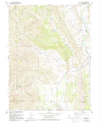
1968 Map of Stonyford
USGS Topo · Published 1994About this map
Stonyford sits at the southern edge of this mid-century survey, positioned where the rugged eastern foothills of the Mendocino National Forest meet the drainage of Stony Creek. The landscape is defined by the transition from steep timbered ridges, such as Brushy Ridge and Auk Auk Ridge, to the fertile openings of Indian Valley and Salt Spring Valley. Local history is anchored by the Indian Valley Sch near the Glenn and Colusa County line, while the uplands are marked by several small mineral prospects and mines. The presence of Sulphur Spring and Salt Spring indicates the complex geology of this watershed, which feeds into the larger course of Stony Creek and its tributary, Little Stony Creek. This period shows the development of numerous 4WD tracks providing access through the Black Diamond Glades and up toward distinctive landmarks like Goat Rock.
Find a feature on this map
26 named features on this map. Tap any name to fly to it.
Don’t see what you’re looking for? This feature index may not catch every label — zoom into the map to look around manually.
Map Details
Editions of this 1968 Stonyford Map
3 editions found
Other maps of this area

1919 · Fruto
USGS Topo · 1:62,500

1919 · Elk Creek
USGS Topo · 1:62,500

1943 · Lodoga
USGS Topo · 1:62,500

1944 · Fruto
USGS Topo · 1:62,500

1948 · Elk Creek
USGS Topo · 1:62,500

1951 · Stonyford
USGS Topo · 1:62,500

1957 · Elk Creek
USGS Topo · 1:62,500

1957 · Ukiah
USGS Topo · 1:250,000
1958 · Fruto
USGS Topo · 1:62,500

1960 · Ukiah
USGS Topo · 1:250,000