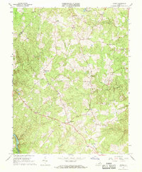
1966 Map of Storck
USGS Topo · Published 1968About this map
Heflin and the crossroads of Hartwood anchor this mid-1960s survey of Stafford County, where rural settlements and community landmarks define the landscape. The region is marked by a network of small churches that served as local anchors, including Rock Hill Ch, Richland Ch, and Antioch Ch. Many place names on this map reflect family-based nodes like Dodds Corner, Davis Corner, and Paynes Corner, highlighting the area's agricultural and social foundations before the significant modern expansion of the corridor.
Find a feature on this map
34 named features on this map. Tap any name to fly to it.
Don’t see what you’re looking for? This feature index may not catch every label — zoom into the map to look around manually.
Map Details
Editions of this 1966 Storck Map
4 editions found
Other maps of this area

1887 · Spottsylvania
USGS Topo · 1:125,000

1889 · Fredericksburg
USGS Topo · 1:125,000

1890 · Mt. Vernon
USGS Topo · 1:125,000

1891 · Mt. Vernon
USGS Topo · 1:125,000

1892 · Fredericksburg
USGS Topo · 1:125,000

1892 · Spottsylvania
USGS Topo · 1:125,000

1894 · Warrenton
USGS Topo · 1:125,000

1894 · Fredericksburg
USGS Topo · 1:125,000

1894 · Mt. Vernon
USGS Topo · 1:125,000

1897 · Mt. Vernon
USGS Topo · 1:125,000